
Courtesy USGSIf you’ve got a hankering to build, say, a new strip mall on an old piece of farmland in most places in this state, you need to make sure that in the process you’re not destroying a stream with fish in it. This makes sense. But there’s a problem: The maps that cities and counties most often use to determine where such streams are located are pretty much useless.As reported Friday in the North Kitsap Herald, the DNR-produced “water typing maps” date as far back as the 1970s, are computer-generated “best guess[es],” and very often don’t conform to reality. For instance, a survey of Cowling Creek north of Suquamish undertaken by the nonprofit Wild Fish Conservancy found that the DNR map left out two-thirds of the watershed, including, the Herald reports, four miles of fish-filled streams. Moreover, the maps were never intended for use by local governments to determine zoning. Instead, DNR spokesman Bob Redling explains to Seattle Weekly, they were (and are) meant to be a “starting point” for loggers figuring out where they can and can’t chop down trees. Local governments, however, often have no alternative but to use the maps, Redling adds, as the state’s Growth Management Act, which governs how 29 of Washington’s 39 counties manage their waterways, requires that the “best available science” be used in so doing. In many parts of the state, and particularly in rural areas, the DNR’s Carter-era guesstimates are the only science available. The problem cuts both ways. On one hand, people build where they shouldn’t and so destroy fish-filled creeks. On the other, a phantom waterway can create unwarranted hurdles for a would-be developer. The obvious solution would be for the state to send out armies of scientist/mappers to map the state’s waterways. But the money that such an undertaking would cost, in lean times such as these, is not in the offing. Follow The Daily Weekly on Facebook and Twitter.
More Stories From This Author


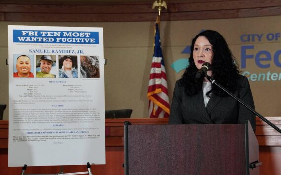
Federal Way murder suspect added to FBI’s Ten Most Wanted Fugitives list
The FBI is offering a $1 million reward for information leading to his arrest.
By
Joshua Solorzano • March 10, 2026 3:00 pm

Foster youth guaranteed full-ride college tuition
OLYMPIA — A bill guaranteeing full‑ride college tuition for all foster youth and students who experienced homelessness passed both legislative…
By Annika Hauer, WNPA Foundation • March 10, 2026 10:53 am

Mercer Island School District faces $13.4M sex abuse claim
School leaders received numerous reports that former high school English teacher Curtis Johnston was “dating” a student but failed to intervene, complaint says.
By Moe K. Clark, InvestigateWest • March 5, 2026 3:08 pm