How We Ended Up With the Great Wall of Waterfront Blight
Published 8:00 am Wednesday, March 7, 2007
Given the acrimonious political debate over the Alaskan Way Viaduct’s replacement, leading to—but certainly not ending with—Tuesday’s mail-in advisory ballot, you’d think the elevated eyesore was controversial evenbefore its 1953 opening. Not true. Everyone loved it then, in part because the duplex waterfront highway was an entirely native solution to the downtown gridlock caused by U.S. Highway 99 dumping cars into both ends of town. It wasn’t a new, forced mandate from Olympia or Washington, D.C., but the fruition of almost three decades of municipal planning—mostly forgotten now, and poorly documented then.
The great bypass route was actually conceived during the 1920s, well before there was any need for it. Seattle still had streetcars; private automobiles were rare; the north–south Pacific Highway 99 was new and clear; and the Depression would soon empty the streets of all but the most necessary traffic. It was then, on a 1927 visit to the Midwest, that local engineer J.W. “Arch” Bollong beheld the majesty of Chicago’s new bilevel Wacker Drive, which still roars today along the shore of theChicago River (and which is best known from the final chase sequence in The Blues Brothers). Though his exact words—and indeed most of his biographical details—are lost to the sands of time, he essentially declared, “Damn, we gotta build us something like that back home on Elliott Bay.” And build it we did.
It took another 26 years, basically the rest of the young traffic engineer’s career, for the northern third of the viaduct to open on April 4, 1953, and it’s unclear whether Bollong lived to see it. His presence isn’t chronicled at the official ribbon-cutting ceremony, and I was unable to locate any of his descendants. But he would have been the happiest man in Seattle that day. Arch Bollong’s story is one of triumph—a cheerful, optimistic, partisan’s view of how problems could be solved with careful planning, popular support, the cooperation of public officials, and sound financing. All of which the viaduct originally enjoyed. In the words of 97-year-old former Washington Gov. Al Rosellini, whose political memory goes back to that era, “I don’t recall there was any particular fuss about it.”
Of course, that may also be because the city approved the project on Christmas Eve during a newspaper strike.
The secret history of the Alaskan Way Viaduct is one of little opposition and even less public scrutiny. The documents I followed through our city library and municipal archives aren’t even remotely complete, and the gaps and literally X-Actoed-out pages hint at a broader problem that haunts us still: a lack of government transparency and accountability. No one can fully account for how the viaduct was built. No one seems able to clearly explain how it ended up under the control of the state. No one appears capable of stopping or starting its successor. Is it any wonder our long-fought clusterduct battle has such long roots?
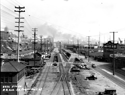
Following his 1927 visit to Chicago,Bollong drew up an elaborate scheme of highway corridors throughout the city, of which the eventual viaduct was just one.”A double-deck roadway should be built on Railroad Avenue,” Bollong wrote in an official report to his superiors at the City Engineer’s office. At the time, Railroad Avenue ran alongside Elliott Bay, following the route that’s now called Alaskan Way. It was basically composed of offshore pilings and wooden decking topped with a maze of railroad tracks and interspersed with open “man traps” through which unlucky souls occasionally fell into Puget Sound. Bollong proposed that the mounds of inconvenient dirt then being blasted off Denny Hill be used as fill to widen and stabilize the avenue and build the viaduct above.
He bolstered his presentation with many photos and impressions of his recent trip. “This Wacker Drive in Chicago and the Riverfront Plaza in St. Louis hold a very close relation to our own Railroad Avenue,” he wrote, “where plans have already been brought forth for the erection of a two-deck roadway, the lower deck to be used for commercial vehicles and the upper for fast-moving passenger traffic.” The viaduct would also provide 5,000 parking spaces beneath it, he noted, “as business and the automobile go hand-in-hand.”
Then, page 42 of his viaduct proposal reads: “See sketch attached.” The next page has been neatly sliced out, like the centerfold in a vintage Playboy someone desperately wanted to keep.
At the time, Bollong’s plan to build a highway over a rail-choked apron of rotting pilings was far-fetched and risky, not to mention that there was no money. Moreover, Railroad Avenue was still somewhat disputed turf. The region’s two great rail monopolies, the Great Northern and the Northern Pacific, had dominated the waterfront since the late 19th century, when young, weak Seattle was desperate to move freight eastward. Their properties and wide rights of way were gradually diminished by the 1905 completion of the rail tunnel (removing a tangle of waterfront tracks from Washington to Stewart streets) and the 1911 creation of the Port of Seattle, which wrested most of the piers away from railroad ownership.
In the mid-’30s the city built a new seawall (yes, the same gribble-infested structure that needs replacing today), which essentially allowed Seattle to push its boundary west and claim the new dry ground beneath Railroad Avenue. The whole area became ripe for development—tabula rasa for certain old transportation plans rolled up in a desk drawer.
With the seawall in place, Bollong’s dusty blueprint was now unfurled. That new land naturally drew the gaze of Mayor William F. Devin, a Democrat and stalwart FDR supporter who held office in consecutive terms from 1942 through 1952. While manpower and federal largesse were tied up during the war years, the city began a stealthy program of condemnation, clearing warehouses, businesses, and other obstacles to the viaduct’s future path. Ultimately, the city spent $1.2 million, or 10 percent of the initial viaduct costs, on securing land for the right of way. None of this money was subject to public vote or any kind of special levy.
Indeed, concerned about a lack of oversight for these expenditures, the Seattle Municipal League, a good-government watchdog group founded during theProgressive Era and still around today, actually sued the city in 1940 for excessive borrowing for its condemnation program. Which halted exactly nothing. People were paying attention to the war in the Pacific during those years, not the war alongElliott Bay. But as Allied troops steadily advanced eastward toward Japan, politicians including Devin began strategizing how to pillage the Federal Highway Aid Act of 1944, which promised a postwar bounty of funding.
The Muni League was particularly irate about the closed-door planning of the viaduct. “As far as we can determine, the only study given to the viaduct was at a meeting on October 19, 1944 at which the City Engineer [Charles L.] Wartelle discussed 25 items in his department’s postwar program,” the Muni League complained in a letter to the city, written after the condemnations were over and officials had begun angling for federal money. According to the League’s letter, Wartelle had admitted in an October ’44 meeting with the City Planning Commission that the viaduct project “may not be needed in the five-year period following the war. However, to play it safe, it was included in the program.” Basically, the viaduct was being placed on the city’s wish list in order to be eligible for the Federal Highway Aid Act. As with the officials who promoted Sound Transit in the ’90s, a primary goal was to not miss out on available federal funds.
Viaduct planning continued through World War II. A few months after the Japanese surrender, a map appeared in the Nov. 18, 1945,Seattle Times that included Mayor Devin’s plan. Shortly thereafter, a curious thing happened: The city’s printers went on strike, effectively putting the Times, P-I, and now-defunct Seattle Star out of business. All that was left was the weekly Municipal News, whichreported on Dec. 22, “Approval of construction of an elevated four-lane arterial on Alaskan Way has been recommended to the city council by the council’s streets and sewers committee.”
The strike didn’t end until Jan. 12. But the next day the Times reported that a formal council vote on the viaduct had taken place during the news blackout. In the city archives, confirmation comes in the form of council Resolution No. 14138, which recommends that “the necessary preparatory measures be taken immediately for the construction of an elevated structure on Railroad Way” and that “the City Engineer is directed to proceed at once with the necessary steps to secure federalaid matching moneys for this project.”
And what was the date for this resolution? Christmas Eve, 1945. Some gift.
The middle stage of viaduct history proceeded quickly and without much interest, like some vaudevillian brought on to juggle balls between acts. On Aug. 19, 1946, the council passed Ordinance No. 75292, creating a funding authority for the roadway. Costs escalated repeatedly, more ordinances condemned property and cleared rights of way, a new mayor was elected, the Times and P-I predictably cheered the project, and the Muni League continued to protest the planning process—or lack thereof. A 1948 editorial from the League decries the city’s “cursory study” of the project. TheMunicipal News continues: “The viaduct was never approved as a project separate from the many other items in the public works program. Rather, the [City Planning] Commission gave a broad endorsement to the entire public improvements program.”
Too little, too late. Hot air wasn’t about to stop the concrete from pouring. Construction on the first third of the viaduct, from Battery to Pike, lasted from 1949 to 1953. It opened on April 4, with sled dogs, a beauty queen, and the ritual ribbon cutting. (The fake oversize scissors didn’t work, and a pocket knife had to be employed. Prophetic?) The state Department of Highways had its own magazine at the time, Highway News, which includes the following piquant observation: “At this point it is interesting to note that unlike the Aurora Bridge [completed in 1932] and the Lake Washington Bridge projects [1940], the Alaskan Way Viaduct met no organized opposition and had very little fanfare. It seems practically everyone in the area agreed this was the route to take through the city.”
Everyone, perhaps, except prominent modernist architect Paul Thiry (designer of KeyArena and other local landmarks), who told the Times, “It will block off all bordering buildings from the bay.” And the city archives include a few prescient protest letters from citizens, like R.S. Hawley of the Central Building Company, who warned of the viaduct: “It would always remain an unsightly structure. It should not be many years before Seattle wakes up to the desirability and the need of redeveloping its waterfront in a high-grade manner, and when that time comes, it will be unfortunate to have a viaduct of the nature proposed encumbering our very valuable waterfront.” Greg Nickels couldn’t have said it better.
Two more sections were built by 1959, connecting U.S. Route 99 to its southern arm in our present-day stadium district. The state estimated that some 32,000 vehicles daily were diverted from city streets. (Today, the viaduct carries three times that amount.) For its first dozen-odd years of highway supremacy, the viaduct stood unquestioned and majestic along the waterfront, a marvelous concrete garland for a can-do age. As Bollong optimistically wrote in a 1947 traffic division report to his bosses, “Now—new worlds to conquer!”
Ramps at Seneca and Columbia streets were added in the ’60s. This made the viaduct less of a thoroughfare and more a means of getting to downtown for residents of the North End and West Seattle. The trend was made more pronounced with the 1965 completion of I-5, which reduced traffic along 99 by two-thirds. Thus Bollong’s original vision of a bypass route was subverted. I-5 became the bypass and 99 the back door to the city, where people mostly worked and didn’t reside. By the 1970s, it came to be seen as a barrier to the waterfront; and by the ’90s, with I-5 increasingly clogged, a bypass of the bypass, and an impediment to downtown living.
Still, since the state now owns the viaduct and high-handedly lectures us about its fate, it’s ironic to note that the city actually paid the lion’s share of the structure’s cost. In a proud 1952 overview of the project in Civil Engineering magazine, City Engineer Ralph Finke itemized the $10.6 million tab thusly: $2.3 million in federal aid, $2.5 from the state, and $5.8 million from the city. This included the city’s condemnation and right-of-way costs—though not, of course, the potential value of that waterfront land in the future.
Today one might reasonably ask, how did Seattle, the instigator and major partner in building the viaduct, lose control of its future destiny? How did Bollong’s innocent Wacker Drive dreams get subsumed into a morass of interagency transportation planning? Therein lies a continuing mystery.
The viaduct, 50 percent funded by the city and 100 percent built on city land, was originally part of the U.S. highway system when it opened. Yet at the same time, the state was considered operator and owner of the highway, even before 99 was downgraded from a federal to state route in the late ’60s. Basically, city and federal involvement with the highway ended with the ink drying on the checks. Seattle appears to have granted the viaduct’s aerial right of way to the state in perpetuity. Where the specific city ordinance or state legislative act may lie within some forgotten archive, no one at WSDOT or SDOT has been able to tell me. Remember the vast warehouse at the end of Raiders of the Lost Ark? It’s something like that.
And this, too, is consistent with the viaduct’s murky origins. “Washington’s Highway Department has been regarded for years as a sort of dynasty that ran itself from within. And a rather expensive one, too,” the Times‘ Ross Cunningham wrote in 1953. “The internal organization has helped elect and defeat several governors. One result has been that the Highway Department ‘ins’ stayed in power despite the outcome of elections.”
We’re about to see that confirmed once again.
I wish I could report a Rosebud, or even a lost ark, amid the musty troves of viaduct birth records, but they belong to the incomplete era of tattered carbons and faded mimeographs. (Which still smell better after 60 years, I might add, than the CD-ROMs and PDFs of today.) Over and over, I heard the same response from well-meaning city and state officials—”Records aren’t so good from the 1940s.” In part, obviously, this is because there was a war on: The press, public, and government workers weren’t so concerned with observing every bureaucratic nicety. Not every meeting note made it into a file; not every document was filmed onto microfiche. The monument that lasted was the viaduct, not its paper trail.
And Arch Bollong was no Robert Moses, the legendary “Power Broker” who built New York City’s great transportation grid—arguably ruining much of the city in the process—by collecting his own tolls and spending them as he saw fit. And our Department of Highways never had the nefarious clout of the Los Angeles Water Department under William Mulholland. There’s no great villain in the viaduct saga, no single individual who can be charged with killing the waterfront, or at least planning its murder, during the prewar era. Because the waterfront as we conceive it now, a desirable public space to be integrated with the rest of the city, simply didn’t exist in those terms back then.
Or, to put it differently: Forget it, Jake, it’s China-duct.
A note on the sources: In addition to publicly available documents at the library and municipal archives, local historian Paul Dorpat supplies the best chronology of the paleo-duct in his 271-page report to the City Council, delivered last year, entitled “Seattle Waterfront: An Illustrated History,” which was based largely on archival clippings from The Seattle Times. Local site HistoryLink.com publishes an excellent overview of state transportation history in its Moving Washington Timeline.